

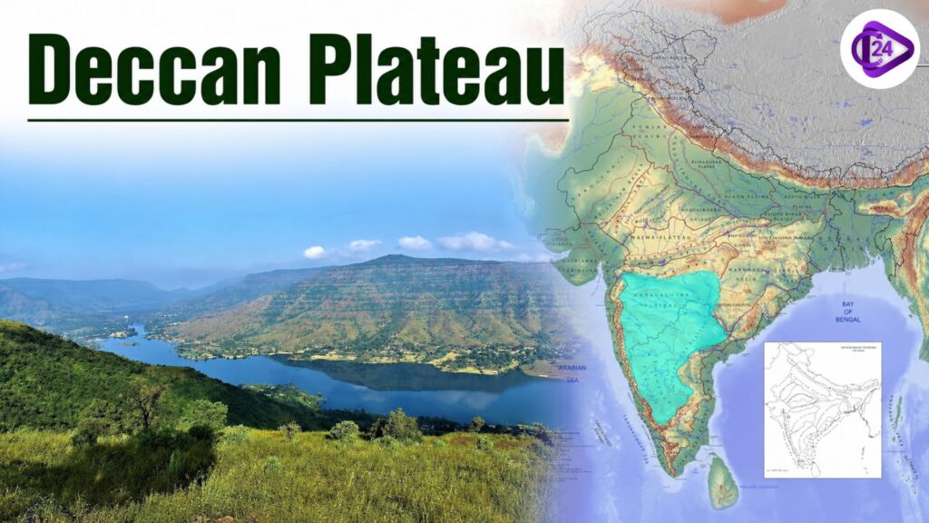
Deccan Plateau is one of the oldest and largest plateau regions in India, which covers much of the southern peninsula of India. It is a triangular plateau separated from the Western Ghats and Eastern Ghats to the south by low hill ranges and from the Himalaya, Satpura and Vindhya ranges to the north. The plateau is composed primarily of black soil, minerals, and biodiversity as a result of large volcanic activity − the Deccan Traps. It is a major driver of the economy in India; industries involved include agriculture, mining and hydropower. It is not just geographically significant but also economically important, as major rivers originate from the Deccan Plateau.
Deccan Plateau Formation
A conservative geological model of the Deccan Plateau is one based on deep erosion, large‐scale volcanism and ancient geology. As per the Geological Survey of India (GSI) as well as the National Centre for Earth Science Studies(NCESS), it is among the oldest landforms on this planet and is part of the Peninsular Shield. The face we see today was largely formed by cataclysmic volcanic eruptions over 66 million years ago, when the Deccan Traps were born.
Key Points on the Formation of the Deccan Plateau
- The Deccan Plateau is a section of the Peninsular Plateau, one of the oldest and most stable geologic regions in India.
- The basement consists primarily of igneous and metamorphic rock with a Precambrian age (more than 540 million years)
- The northwestern part of the plateau consists of the Deccan Traps, one of the largest volcanic provinces worldwide.
- The Deccan Traps originated due to massive fissure volcanic activity in the terminal Cretaceous, around 66 million years ago.
- Repeated lava flows spilling out over an area of some 500,000 square kilometres built up domed layers of basalt rock.
- The eruption is linked to the Réunion mantle plume (hotspot) that generated extensive lava flows.
- This process of weathering over several million years led to the black cotton (Regur) soil, which is very fertile and suited especially for crops such as cotton, soybean, sugarcane and pulses.
- Which weathered over the ages, with rivers like Godavari, Krishna, Kaveri and Narmada eroding increasing surface defects on the plateau.
- Because of its archaic geological framework, it has much mineral wealth; the Deccan Plateau is especially rich in iron ore, manganese, bauxite and mica, limestone, and copper.
- The plateau is tectonically stable (within the Indian Shield) as it does not straddle an active plate boundary.
Deccan Plateau Resources
The Deccan Plateau is India’s second richest region in mineral, water, forest and agricultural wealth. It is largely composed of Archean rocks, rich in mineral deposits and black soil, enabling enormous contribution to Indian mining, agriculture and industry.
Mineral Resources
- Availability of iron ore in large quantities, with a prominent share in Karnataka and Chhattisgarh.
- Leading Manganese Ore Manufacturer in Maharashtra, Madhya Pradesh & Karnataka.
- It is found in abundance as bauxite, which is an ore from which aluminium is extracted. Large deposits of this ore can be found in Maharashtra, Andhra Pradesh and Odisha.
- Limestone: This is used in the cement industry.
- The plateau contains deposits of mica, copper, gold and granite.
- Kolar Gold Fields in Karnataka were previously one of the deepest gold mines of India.
Soil Resources
- Composed of Decomposed Basaltic Lava with presence of Black Cotton Soil (Regur Soil).
- Black soil is moisture-retentive and a good soil for growing cotton.
- Different areas of the plateau also contain red, laterite and mixed soils.
Water Resources
Source region of many important peninsular rivers
- Godavari
- Krishna
- Kaveri
- Tungabhadra
- Bhima
- A few large dams and reservoirs power irrigation and hydroelectricity generation.
Forest Resources
The plateau is covered in extensive areas of tropical deciduous forest
Important tree species include:
- Teak
- Sal
- Sandalwood
- Bamboo
- Neem
- Forests supply timber, medicinal plants, bamboo, lac, gums and others.
Agricultural Resources
Fertile black soil gives support for cultivation of :
- Cotton
- Sugarcane
- Soybean
- Groundnut
- Millets
- Pulses
- Maize
- Irrigated lands produce fruits, vegetables and spices also.
Energy Resources
- Big hydropower schemes on the Godavari, Krishna and Kaveri river systems.
- Huge potential for solar and wind energy, especially in Maharashtra, Karnataka, Telangana and Andhra Pradesh.
- Coalfields of the adjoining plateau regions fulfil the thermal power needs.
Sub-Plateaus of the Deccan Plateau
The Deccan Plateau is divided into several sub-plateaus based on relief, geological structure, river systems, and regional characteristics. These sub-plateaus are important for geography and competitive examinations.
| Sub-Plateau | Location | Key Features |
| Maharashtra Plateau | Maharashtra | Largest part of the Deccan Plateau; formed by Deccan Trap basalt; known for black cotton soil (Regur) and cotton cultivation. |
| Karnataka Plateau (Mysore Plateau) | Karnataka | Composed mainly of ancient granite and gneiss rocks; rich in gold, iron ore, and manganese; drained by the Krishna and Kaveri rivers. |
| Telangana Plateau | Telangana and parts of Andhra Pradesh | Made up of granite rocks; characterised by undulating terrain, red and black soils, and rich mineral resources. |
| Rayalaseema Plateau | Southern Andhra Pradesh | Semi-arid plateau with red soils; known for groundnut cultivation and granite deposits. |
| Marathwada Plateau | Central Maharashtra | Part of the basaltic Deccan Trap region; mainly dependent on monsoon rainfall; important for cotton, pulses, and sugarcane cultivation. |
Also Read
Agricultural Importance of the Deccan Plateau
The Deccan Plateau is one of the most important agricultural regions of India due to its fertile black soil (Regur soil), extensive river systems, and favourable climatic conditions. The croplands of the plateau offer a living for millions of farmers and are important in producing cash crops, food grains, pulses, oilseeds and horticultural crops. More extensive irrigation projects on state rivers like Godavari and Krishna and Kaveri have also boosted farm output.
Geographical Significance of Deccan Plateau
-
- Black Cotton Soil (Regur Soil): It is known for the black soil of the well-developed plateau region, which is ideal for cotton cultivation as it is formed from weathered basaltic lava.
- Primary producer of Cotton: The Deccan Plateau is the most important cotton-producing area in India, particularly in five states including Maharashtra, Telangana, and Karnataka.
- Diverse Crops: Commonly cultivated crops include:
- Cotton
- Sugarcane
- Soybean
- Groundnut
- Jowar (Sorghum)
- Bajra (Pearl Millet)
- Pulses (Tur, Gram)
- Maize
- Wheat (in irrigated areas)
- Horticulture Hub: The plateau yields fruit and commercial crops such as grapes, pomegranate, banana, orange, mango, turmeric and spices.
- Irrigation Development: Dams and canals on the Godavari, Krishna, Kaveri, Bhima, and Tungabhadra rivers enable farming all year round.
- Cash Crop Production: These are Cotton, sugarcane, tobacco and oilseeds that provide a substantial share to the rural economy of India.
- Agro-Based Industries: Textile, Sugar, Edible Oil, Food Processing and Cotton Ginning industries are also found due to agricultural productivity across the plateau.
- Animal Husbandry: Grasslands are home to livestock. Cowboys, sheepdogs and herders herd vast meadows for cattle, sheep and goats here as well.
- Creation of Employment: The Deccan Plateau had a semi-arid climate-based economy which relied completely on agriculture, and a large part of the rural population in this region were situated here due to farming.
- Food Security: The region is the major producer of cereals, pulses, oilseeds and commercial crops in India.