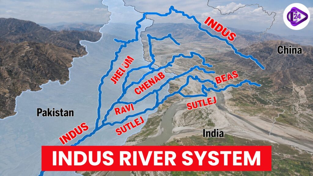
The Indus River System, which covers the harshest and driest parts of South Asia, having originate place from China & flowing through India and Pakistan. The Indus River originates near Lake Manasarovar in the Tibetan Plateau, and traverses NW into Ladakh before entering Pakistan and emptying into the Arabian Sea. At over 3180 km, it is one of the longest rivers in Asia. Six main rivers—Indus, Jhelum, Chenab, Ravi and Sutlej, combined with the smaller Beas, compose a large drainage network. The system is well known for offering the cradle of the ancient Indus Valley Civilisation, and it continues to be important for agriculture, irrigation, hydropower generation and regional water security.
Indus River System
Indus River System is basically comprised of 6 big rivers: the Indus, Jhelum, Chenab, Ravi & Beas and Sutlej. All of these rivers, except for the Beas, originate in or around the Himalayas. The Indus River System provided for the ancient and now dead Indus Valley Civilisation but still provides significant socio-economic growth in South Asia.
Indus River System Origins
The Indus River System originated in the trans-Himalaya near Lake Manasarovar and Mount Kailash on the Tibetan Plateau. At approximately 5,100 metres above sea level on the southern slopes of the Kailash Range, in Tibet (China), west of the Bokhar Chu glacier, rises the main Indus River. The river originates from sources in the northwestern region of Tibet, then flows northwest through Ladakh (India), and into Pakistan, before emptying into the Arabian Sea. The Independent Punjab has an almost permanent water supply available during the whole year due to its major tributaries—Jhelum, Chenab, Ravi, Beas and Sutlej—which have man-made sources of water from our frozen rivers’ glaciers and springs lying in the Himalaya region(s) of Malwa.
Indus River System, Major Left Bank Tributaries
| Tributary | Origin | Key Course & Features | Confluence |
|---|---|---|---|
| Zanskar River | Zanskar Range, Ladakh | Flows through the cold desert of Ladakh; forms deep Himalayan gorges; famous for the winter Chadar Trek. |
Joins the Indus at Nimmu, near Leh. |
| Suru River | Panzella Glacier, Ladakh | Flows through the fertile Suru Valley near Kargil; supports irrigation, barley, and apricot cultivation. |
Merges with the Indus downstream in Ladakh. |
| Jhelum River | Verinag Spring (Chashma Verinag), Pir Panjal Range, Jammu & Kashmir | Known as Vitasta in ancient texts; flows through Srinagar and Wular Lake; total length of about 720 km. |
Joins the Chenab River in Pakistan. |
| Chenab River | Formed by the confluence of the Chandra and Bhaga rivers at Tandi, Himachal Pradesh; fed by glaciers near Baralacha La Pass. |
Known as Asikni or Chandrabhaga; largest tributary of the Indus River System. |
Joins the Indus River in Pakistan through the Panjnad system. |
| Ravi River | Near Rohtang Pass, Chamba district, Himachal Pradesh | Known as Iravati in ancient texts; flows between the Pir Panjal and Dhauladhar ranges; length of about 720 km. |
Merges with the Chenab River in Pakistan. |
| Beas River | Beas Kund near Rohtang La Pass, Himachal Pradesh | Flows entirely through India for about 470 km; important for irrigation and hydropower generation. |
Joins the Sutlej River at Harike, Punjab. |
| Sutlej (Satluj) River | Lake Rakshastal, near Lake Manasarovar, Tibet | Longest tributary of the Indus; enters India through Shipki La Pass; total length of about 1,450 km. |
Joins the Chenab through the Panjnad River before entering the Indus in Pakistan. |
| Panjnad River | Formed by the confluence of the Jhelum, Chenab, Ravi, Beas, and Sutlej rivers in Punjab, Pakistan. |
Represents the combined flow of the five rivers of Punjab. | Joins the Indus River near Mithankot, Pakistan. |
Indus River System Right Bank Tributaries
| Tributary | Origin | Key Course & Features | Confluence |
|---|---|---|---|
| Shyok River | Rimo Glacier, Karakoram Range | Flows through northern Ladakh; receives the Nubra River; forms a distinctive V-shaped bend around the Karakoram Range; characterised by a braided channel due to glacial melt. |
Joins the Indus River near Skardu, Gilgit-Baltistan. |
| Nubra River | Siachen and Nubra glaciers, eastern Karakoram Range | Flows through the cold desert of the Nubra Valley; supports agriculture and settlements in Ladakh. |
Merges with the Shyok River near Diskit, Ladakh. |
| Gilgit River | Shandur region, Hindu Kush Range | Flows through the Gilgit Valley; fed by numerous glaciers and mountain streams; supports irrigation and settlements in Gilgit-Baltistan. |
Joins the Indus River near Juglot, Pakistan. |
| Hunza River | Hispar and Batura glaciers, Karakoram Range | Drains the Hunza Valley; carries substantial glacial meltwater; important for irrigation and local livelihoods. |
Merges with the Gilgit River near Gilgit, Pakistan. |
Son River: Origin, Map, Location, & Facts
Indus River System States & Cities Covered
Indus River System: Spread in China (Tibet), India and Pakistan. In India, its basin includes the Union Territories of Ladakh and Jammu & Kashmir as well as Himachal Pradesh, Punjab, Haryana and Rajasthan Important cities along the route of the system include Leh and Kargil (Indus, Suru), Srinagar and Anantnag (Jhelum), Kishtwar (Chenab) as well as Chamba (Ravi), Mandi and Kullu (Beas), Shimla and Bilaspur (Sutlej) in addition to numerous other canal-fed regions near Amritsar, Ludhiana, Ferozepur, Sirsa, Hanumangarh. Outside India, it also passes through Gilgit and Skardu cities in Pakistani-held Kashmir, before travelling onward to Lahore, Multan and Karachi, where the Indus and its tributaries provide agriculture, industrial and urban water supplies.
Indus Waters Treaty 1960
- The Indus Water Treaty was signed on Sept 19, 1960, in Karachi between India and Pakistan, with the World Bank as signatory & Facilitator.
- Signed: Jawaharlal Nehru (India), Ayub Khan (President of Pakistan)
- The treaty, which governs the sharing of the waters of six rivers in the Indus River System.
- India was assigned Eastern Rivers- Ravi, Beas and Sutlej- for full use.
- India had received the use of limited Western Rivers—Indus, Jhelum and Chenab — which meant that Pakistan should have full control over them.
- India was allowed to develop run-of-the-river hydropower projects on the Western Rivers as long as the projects followed certain prescribed conditions.
- It created the Permanent Indus Commission (PIC) to share data and work together.
- It has a 3-tier dispute resolution structure of PIC, Neutral Expert, & Court of Arbitration.
- Indus Waters Treaty is often considered one of the oldest transboundary water-sharing agreements in existence to date.
Indus River System: Key Features
- South Asia’s third largest river system, covering China (Tibet), India and Pakistan.
- The upper reaches of the Indus originate in proximity to Lake Manasarovar and Mount Kailash along the Tibetan Plateau.
- With a length of around 3180 km, it is one of the longest rivers in Asia.
- The area of the basin is approximately 1.12 million square kilometres.
- There are six main rivers: Indus, Jhelum, Chenab, Ravi, Beas, and Sutlej.
- Note: The Indus is the westernmost Indian river system of the Himalayas.
- The majority of the tributaries are snow-fed and glacier-fed, as a result keeping water flowing continuously for the year.
- The river system is fed by the Himalayan, Karakoram, Hindu Kush and Trans-Himalayan ranges.
- It utilizes great amount for irrigation, agriculture, hydropower production and drinking water.
- The ancient Indus Valley Civilisation, one of the earliest urban civilisations of the world, flourished in this system.
- There are many representative landscapes from cold deserts at high elevations in Ladakh through the fertile plains of Punjab and Sindh.
- The Indus Waters Treaty (1960) prescribes how available water is shared between India and Pakistan.