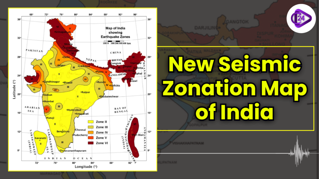
Previously, the Indian landmass was defined into four earthquake zones, including Zones II, III, IV, and V.
Adds a new highest risk Zone VI, with the whole Himalayan arc being covered by that new Zone VI for the first time. Zonal constraints: This is now automatically classified as higher risk. Hazard mapping: This gives importance to geological conditions rather than administrative boundaries.
India’s Earthquake Vulnerability
-
The number of moderate to high seismic hazard areas (previously 59 percent) is 61 percent of the territory of India.
-
An area of 75 percent of India's population is in the seismically active areas.
-
Promotes retrofit of the old buildings in risky regions.
-
Prohibits building in soft sediments or active fault lines.
-
Encourages the implementation of the standard building codes in the Himalayan and other vulnerable areas.
-
NDMA establishes federal disaster management policies.
-
Disaster plans at the state level are developed and executed by SDMAs.
-
The National Seismological Network keeps watch on earthquake activities in India.
-
Study of early warning systems of earthquakes.
Previous Year Question Based on Earthquake Zone
| Exam & Year | Question | Options | Answer |
|---|---|---|---|
| UPSC Prelims 2023 | Which of the following percentages of India’s land falls in high seismic zones according to the updated map? | A. 10% B. 20% C. 30% D. 40% |
C. 30% |
| SSC CGL 2022 | India is divided into how many seismic zones as per BIS (Bureau of Indian Standards)? | A. 3 B. 4 C. 5 D. 6 |
C. 5 |
| RRB JE 2021 | Which region of India falls under the highest seismic hazard zone? | A. Indo-Gangetic plains B. Himalayan region C. Western Ghats D. Deccan plateau |
B. Himalayan region |
| UPSC Prelims 2021 | The National Seismological Network in India is responsible for? | A. Monitoring earthquakes B. Flood control C. Cyclone prediction D. Soil erosion studies |
A. Monitoring earthquakes |
| SSC CHSL 2020 | Earthquake-prone zones of India are classified on the basis of? | A. Population density B. Seismicity and past earthquake records C. Rainfall D. River systems |
B. Seismicity and past earthquake records |
| State PCS 2019 | Which authority is responsible for implementing disaster management plans in Indian states? | A. NDMA B. SDMA C. ISRO D. NDRF |
B. SDMA |
| UPSC 2018 | National Disaster Management Authority (NDMA) functions under which ministry? | A. Ministry of Home Affairs B. Ministry of Earth Sciences C. Ministry of Defence D. Ministry of Environment |
A. Ministry of Home Affairs |
Expected Questions for Seismic Zone of India
Question 1: Which zone on the earthquake map of India represents the highest seismic risk?
a) Zone II
b) Zone III
c) Zone V
d) Zone VI
Answer: d) Zone VI
Description: Zone VI (dark brown colour) indicates areas of very high seismic risk, including parts of the Himalayas, Northeast India, and Andaman & Nicobar Islands.
Question 2: Which major city falls under Zone V?
a) Delhi
b) Jaipur
c) Mumbai
d) Bengaluru
Answer: a) Delhi
Description: Zone V (red color) represents high seismic hazard areas, including Delhi, Patna, and parts of Gujarat and Maharashtra.
Question 3: Which state in India is entirely in Zone II (low seismic risk)?
a) Gujarat
b) Karnataka
c) Kerala
d) West Bengal
Answer: b) Karnataka
Description: Zone II (yellow) indicates low seismic hazard, covering most of southern India, including Karnataka, Kerala, and parts of Andhra Pradesh.
Question 4: Port Blair in the Andaman & Nicobar Islands falls under which earthquake zone?
a) Zone III
b) Zone IV
c) Zone V
d) Zone VI
Answer: d) Zone VI
Description: The Andaman & Nicobar Islands are in Zone VI due to their location near tectonic plate boundaries, making them highly prone to earthquakes.
Question 5: The city of Mumbai falls under which earthquake zone?
a) Zone II
b) Zone III
c) Zone IV
d) Zone V
Answer: d) Zone V
Description: The western coast of India, including Mumbai, is in Zone V, which indicates a high risk of earthquakes.
Question 6: Which of the following cities is in a moderate-risk zone (Zone III)?
a) Bhopal
b) Jaipur
c) Hyderabad
d) Shillong
Answer: c) Hyderabad
Description: Zone III (light yellow-brown) represents moderate seismic risk, including Hyderabad, Chennai, and parts of central India.
Question 7: Which of the following states has areas in both Zone IV and Zone V?
a) Gujarat
b) Maharashtra
c) Rajasthan
d) Uttar Pradesh
Answer: a) Gujarat
Description: Gujarat has regions in Zone IV (orange) and Zone V (red), reflecting both moderate and high seismic risk areas.
Conclusion
The recent 2025 Seismic Zonation Map of India re-establishes the risk of an earthquake with the whole Himalayan belt in the Zone of highest risk of VI. Moderate-to-high hazard (61 percent of the landmass in India) covers safer urban planning, stricter building codes, and better disaster preparedness; planning infrastructure and policies to match the seismic assessment of science.