


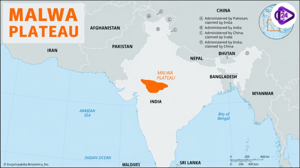
The Malwa Plateau is an essential part of the volcanic plateau in west-central India, consisting of almost the whole of Madhya Pradesh and southeastern Rajasthan. It is part of the Central Highlands and has black cotton soil (Regur soil), which makes it one of the major agricultural areas in India. A region of basaltic rocks and waves that were created from Deccan Trap volcanic eruptions forms the plateau. It is fed by the Chambal, Betwa, Kali Sindh, Mahi and Parvati rivers. Malwa Plateau history, culture, and trade, while agriculture and industries are supported by rich biodiversity.
Malwa Plateau History
- Malwa Plateau is an important historical-cultural region of ancient India, which was a centre of trade, agriculture and culture.
- The region constituted a part of the Avanti Kingdom (a Mahajanapada) during the 6th century BCE, and its capital was Ujjain.
- This was followed by the rule of the Maurya Empire, the Shunga, Satavahana, Gupta and Paramara dynasties that played a vital role in framing the politics and culture of this land.
- Paramara kings, particularly King Bhoja (1010–1055 CE), patronised literature and education, architecture and irrigation, turning Malwa into an important centre of learning.
- In the medieval era, the area was under the domination of the Delhi Sultanate, the Malwa Sultanate and later on by the Mughal Empire.
- The Marathas, and the Holkar dynasty in particular, became prominent in the 18th century, establishing themselves as a dominant power, and the city of Indore rose to become an important seat of administration and commerce.
- At present, the Malwa Plateau is best known for many ancient cities and monuments/temples/forts of the past, and remains a focus of study for historians and cultural heritage researchers/tourists.
Malwa Plateau Rivers
- The Malwa Plateau is drained by some crucial rivers pouring into western and central India to support agriculture, irrigation, supply of drinking water and hydroelectric power generation.
- The Chambal River is the largest in terms of volume, running through the plateau; it originates at Janapav Hills (Mhow, Madhya Pradesh) and is one of the major tributaries of the Yamuna.
- The Betwa River originates near Bhopal in northeastern Madhya Pradesh and empties into the Yamuna; it is highly important for irrigation throughout the whole of Madhya Pradesh and Uttar Pradesh.
- It rises in the Vindhyan region of Madhya Pradesh and joins the Chambal River after traversing parts of Rajasthan, among other places, where it is known as the Kali Sindh River.
- Another major tributary is the Parvati River, which provides irrigation to the Malwa region.
- Mahi rises in the Vindhyan Hills near Sardarpur (Madhya Pradesh) and flows west via Rajasthan and Gujarat to the Arabian Sea.
- Other important rivers related to the plateau include the Gambhir, Kshipra (Shipra), and Shivna(rivers that have cultural and economic importance).
- These rivers create fertile alluvial deposits, have irrigation potential, and hydroelectric power generation potential—and supply water to industries and urban centres, making them important in the economy of this region.
Malwa Plateau Climate
- Malwa Plateau has a tropical monsoon climate, with hot summers, a rainy monsoon season, and cool dry winters.
- The summer is mostly between the months of March to June, with temperatures between 30°C and 42 °C, whereas May is typically the hottest month.
- The southwest monsoon, which is active from late June to September, accounts for most of the 800–1,200 mm of precipitation received annually.
- Winter: it is the best time from November to February; it’s a season of rain, with temperatures ranging from about 8 °C to 25 °C.
- The moderate temperatures that exist on the plateau are attributed to its location, which lies approximately 500–600 metres above sea level and therefore much higher than the plains that surround it.
- Due to rain, soybean, wheat, maize, gram, and pulses can be cultivated in the region, and hence this is an important agricultural area.
- The climate also favours the growth of dry deciduous forests, grasslands and diverse flora and fauna over the plateau.
- In general, the Malwa Plateau is among Central India’s most advantageous districts for farming due to its tropical climate and productive soils.
Malwa Plateau Vegetation
- Most of the Malwa Plateau is dominated by Tropical Dry Deciduous Forests, given its tropical monsoon climate and moderate annual rainfall.
- The natural vegetation mainly includes teak (Tectona grandis), sal (limited in areas), bamboo, tendu, Mahua, neem and Babul, Palash and khair trees.
- Among them, Teak is the most commercially important and widespread species in western Madhya Pradesh.
- The plateau also supports numerous shrubs, grasses, medicinal plants, and seasonal herbs that enhance the region’s biodiversity.
- The forests are home to various forms of wildlife, including leopards, sloth bears, deer, jackals and wild boars, as well as several types of birds and langurs.
- Plantlife is crucial to controlling soil erosion, maintaining groundwater reserves, regulating local climate and keeping the ecosystem intact.
- The black blanket of soil covering much of the plateau is fertile, and it has been largely cleared for agriculture. Firewood collection to supplement coal burned by industry and homes also erodes natural forests across large swathes of the region.
- Various sustainable afforestation and forest conservation programmes have been initiated to conserve biodiversity in the plateau area and degraded forest areas.
Also Read
| Yamuna River System | Son River |
| Jhelum River System | Indus River System |
| Godavari River System | Indian River Systems |
| Kaveri River | Narmada River Explained |
| Krishna River System | Sutlej River System |
Malwa Plateau Geographical Significance
- The Malwa Plateau is a major region of the Central Highlands and Peninsular Plateau, as well as being an integral part of India’s physical geography.
- The Deccan Trap (lava flows) deposited basaltic rock in the region that resulted in mineral-rich black cotton (Regur) soil and made this area one of India’s major agricultural areas.
- The plateau is the watershed area of many important rivers such as Chambal, Betwa, Kali Sindh, Parvati, Kshipra and Mahi, which supports irrigation and water.
- The plateau has an average elevation of about 500–600 metres (1,600–2,000 ft) and experiences a comparatively milder climate than the plains surrounding it.
- It serves as a natural transition between the Aravalli Range, Vindhya Range, and the Deccan Plateau in India while connecting north to south of the country.
- This fertile land and favourable climate facilitate the growth of soybeans, wheat, gram, maize, as well as pulses in extremely large numbers, making this area one of the biggest agricultural producers.
- The plateau has always been a significant route of transportation and trade in the history of western, northern and central India, as cities like Indore, Ujjain, Ratlam and Dewas are part of this historical route.
- The geographical features of Chhattisgarh play a crucial role in agriculture, water resources, biodiversity development, planning and the economy of central India.
FAQs on Malwa Plateau
The Malwa Plateau is located in west-central India, covering most of western Madhya Pradesh and extending into southeastern Rajasthan. It forms an important part of the Central Highlands of the Peninsular Plateau.
The Malwa Plateau was formed by the Deccan Trap volcanic eruptions during the late Cretaceous period. It is mainly composed of basaltic lava rocks, which weathered to form fertile black cotton (Regur) soil.
The major rivers flowing through or originating from the Malwa Plateau include the Chambal, Betwa, Kali Sindh, Parvati, Mahi, Kshipra (Shipra), Gambhir, and Shivna rivers.
The Malwa Plateau is important because of its fertile black soil, rich agricultural production, volcanic origin, historical significance, major river systems, and strategic location. It is one of India's leading producers of soybean, wheat, gram, and maize.
The plateau is mainly covered with Tropical Dry Deciduous Forests, where teak, bamboo, mahua, neem, babul, palash, and khair are the dominant tree species. Much of the region has also been converted into agricultural land due to its fertile soil.