

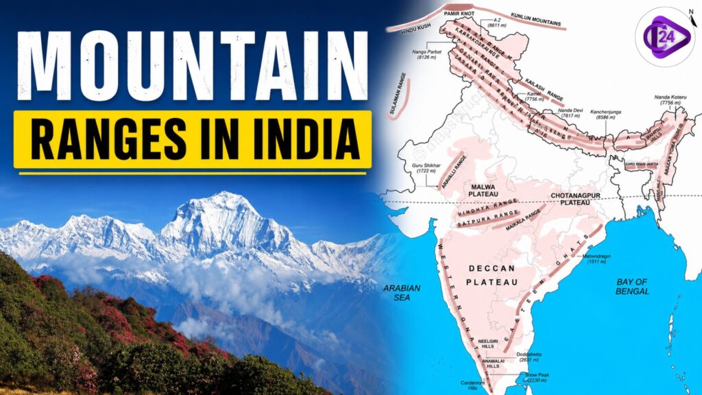
Mountain Ranges: India has an extensive system of mountain ranges which delimit its physical geography and commercial resources. These mountains, extending from the snow-laden Himalayas in the north to the ancient Aravalli Range, the biodiversity-enriched Western Ghats and the beautiful Eastern Ghats, affect the climate of India, river system, agriculture, forests, and biodiversity.
They are also of great historical, cultural and economic importance through the support of tourism, hydro-electricity generation, and rich mineral resources. In this article, we are going to provide you with information about the mountains in India, such as their location, which states they fall in, and how high these peaks are. In this article, we provide an exhaustive list of major mountain ranges of India along with their salient features in a simple and easily understandable manner.
Major Mountain Ranges in India 2026
Mountain ranges of India are one of the important physical features in India and affect climate, rivers, biodiverse regions, and natural resources. Whether it be the snow-clad peaks of the mighty Himalayas or the rocky hills of the Aravalli, Western Ghats and Eastern Ghats, these ranges are important not only for ecology but also for agriculture, tourism and economic development.
The Himalayan Range
The Himalayas are the youngest and among the tallest fold mountain systems in the world. Founded millions of years ago from a collision between the buoyant Indian Plate and the stiff Eurasian Plate. Himalayas snag the Indian subcontinent in a natural barrier from the Tibetan Plateau.
They are critical to regulating India’s climate by intercepting cold air from Central Asia and acting on the Indian monsoon system. The origin of the major rivers of India, like Ganga, Yamuna and Brahmaputra, is provided by the glaciers of Himalaya.
Key Facts of Himalayas – Mountain Ranges
| Feature | Details |
| Type | Young Fold Mountains |
| Length | About 2,500 km |
| Width | 160–400 km |
| Highest Peak | Mount Everest (8,848.86 m) |
| Location | India, Nepal, Bhutan, China & Pakistan |
| Main Rivers Originating | Ganga, Yamuna, Brahmaputra |
| Important Glaciers | Gangotri, Siachen, Zemu |
A. Greater Himalayas (Himadri) – Mountain Ranges
The northmost and highest Himalayan range is called the Greater Himalayas/Himadri. There are some of the tallest peaks in the world, and it stays snowed throughout the year.
Important Features
- Average height: Around 6,000 metres
- Permanent snow-covered zone
- Contains the highest Himalayan peaks
- Source of major glaciers
- Important Peaks
- Mount Everest – 8,848.86 m
- Kanchenjunga – 8,586 m
- Nanga Parbat – 8,126 m
- Important Glaciers
- Gangotri Glacier
- Yamunotri Glacier
- Zemu Glacier
B. Lesser Himalayas (Himachal) – Mountain Ranges
The ranges of the Lesser Himalayas, or Himachal, extend southward from the Himadri range. They can be rocky, large plains, valleys and meadows with tall forests.
This is the most famous region for hill stations and tourism.
Important Features
- Average elevation: 3,700–4,500 metres
- Contains beautiful valleys and forests
- Suitable for human settlement
- Major Ranges
- Pir Panjal Range
- Dhauladhar Range
- Mussoorie Range
- Nag Tibba Range
- Famous Hill Stations
- Shimla
- Mussoorie
- Nainital
- Dharamshala
C. Outer Himalayas (Shivalik) – Mountain Ranges
The southernmost and youngest Himalayan range is the Shivalik Range. We hold it hostage to loose sediments deposited by rivers and so subject to severe erosion.
Important Features
- Height: 600–1,500 metres approximately
- Made of gravel and sediments
- Incorporates famous valleys, Doon Valleys
- Important Valleys
- Dehradun Valley
- Kotli Doon
- Patli Doon
Karakoram Range
This is the Karakoram Range, which is one of the latest and most incredible mountain systems in the world. It is situated in the north of India, mainly in Ladakh, and borders Pakistan and China.
Key Facts of Karakoram Range
| Feature | Details |
| Location | Ladakh, India; Pakistan & China |
| Highest Peak | K2 (8,611 m) |
| Type | High mountain range |
| Famous Glacier | Siachen Glacier |
Important Glaciers
- Siachen Glacier
- Baltoro Glacier
- Biafo Glacier
- Hispar Glacier
Purvanchal Range (Eastern Hills) – Mountain Ranges
The Purvanchal Range is part of the Himalayan system from the northeastern side of India. As the Dihang River passes, these hills bend south to become India’s eastern limit.
Location
- Arunachal Pradesh
- Nagaland
- Manipur
- Mizoram
- Tripura
- Assam
Highest Peak
Dapha Bum – 4,570 metres
Major Hills
- Patkai Hills
- Naga Hills
- Mizo Hills
- Manipur Hills
Aravalli Range
The Aravalli Range is one of the oldest mountain ranges in the world. It was formed during the Precambrian period and has been highly eroded over millions of years.
It extends from Delhi through Rajasthan to Gujarat.
Key Facts of Aravalli Range
| Feature | Details |
| Location | Delhi, Haryana, Rajasthan, Gujarat |
| Length | Around 700 km |
| Highest Peak | Guru Shikhar (1,722 m) |
| Type | Residual Mountains |
Western Ghats (Sahyadri Hills) – Mountain Ranges
Western Ghats, also called Sahyadri Hills, are among the most significant mountains of India. They are located adjacent to the western coast of India, from Gujarat to Kerala.
Most of the Indian monsoon system is influenced by Western Ghats, and also one of the world’s eight “hottest hotspots” of biological diversity. They have also been declared a UNESCO World Heritage Site in light of their unique ecosystem.
Key Facts of Western Ghats
- Type: Block Mountains
- Length: Approximately 1,600 km
- Where: East Coast of India from Gujarat to Kerala
- Most important peak: Anamudi: 2695 m, Kerala
- Local Name: Sahyadri Hills
- Heritage status: UNESCO World Heritage Site
States Covered by Western Ghats
- Gujarat
- Maharashtra
- Goa
- Karnataka
- Kerala
- Tamil Nadu
Major Peaks of Western Ghats
- Anamudi (2,695 m) – South India’s highest peak in Kerala
- Doddabetta (2637 m): The highest peak of Nilgiri Hills
- Mullayanagiri (1,930 m): Karnataka’s highest peak
Important Sub-Ranges
- Nilgiri Hills
- Anaimalai Hills
- Cardamom Hills
- Palani Hills
Eastern Ghats
Eastern Ghats: The Eastern Ghats are the mountain ranges running along the eastern coast of India. As opposed to the Western Ghats, these are discontinuous and interrupted by numerous large rivers.
These mountains, which are home to priceless minerals and forests, represent a vital component of eastern India’s ecological fabric.
Key Facts of Eastern Ghats
- Type: Ancient Discontinuous Mountains
- Location: Eastern coast of India
- Tallest Mountain: Jindhagada Peak (1,690 m), Andhra Pradesh
- Natural: Wrecked and desertified mountain range
States Covered by Eastern Ghats
- Odisha
- Andhra Pradesh
- Telangana
- Tamil Nadu
- Parts of Karnataka
Major Rivers Crossing Eastern Ghats
- Mahanadi River
- Godavari River
- Krishna River
- Kaveri River
Important Hills of Eastern Ghats
- Nallamala Hills
- Javadi Hills
- Shevaroy Hills
- Palkonda Hills
- Mahendragiri Hills
Vindhya Range
One of the major ranges of central India, Vindhya Range is a series of ridges in western/middle India. My son thought that it separates the Northern Plains from the Deccan Plateau and lies almost parallel to the south of the Narmada River.
Key Facts of Vindhya Range
- Type: Ancient Discontinuous Mountain Range
- Location: Central India
- Tallest Peak: Sad-Bhawna Shikhar (752 m)
States Covered by Vindhya Range
- Madhya Pradesh
- Uttar Pradesh
- Bihar
- Chhattisgarh
Satpura Range
Located south of the Vindhya Range, Satpura Range stretches across central India. It divides the Narmada valley from the Tapi valley.
Key Facts of Satpura Range
- Type: Uplifted mountain range
- Location: Central India
- Highest Peak: Dhupgarh (1,350 m)
- Biggest Peak of Central India : Dhupgarh, Madhya Pradesh
States Covered by Satpura Range
- Madhya Pradesh
- Maharashtra
- Chhattisgarh
- Important Hills
- Mahadeo Hills
- Maikal Hills
- Gawilgarh Hills
Nilgiri Hills
The Nilgiri Hills, which means “Blue Mountains”, stand at the confluence of Tamil Nadu, Kerala and Karnataka.
They are a crucial connecting link between the Western Ghats and Eastern Ghats, are known for tea plantations, forests as well as their picturesque beauty.
Key Facts of Nilgiri Hills
- Location: Tamil Nadu, Kerala, Karnataka
- Highest Peak: Doddabetta (2,637 m)
- Part of: Western Ghats
- Notable For: Tea estates, forests & hill stations
Important Places
- Ooty (Udhagamandalam)
- Coonoor
- Mudumalai Wildlife Sanctuary
Also Read
| Yamuna River System | Son River |
| Jhelum River System | Indus River System |
| Godavari River System | Indian River Systems |
| Kaveri River | Narmada River Explained |
| Krishna River System | Sutlej River System |
Mountain Ranges in India FAQs
- Greater Himalayas (Himadri)
- Lesser Himalayas (Himachal)
- Outer Himalayas (Shivalik)