

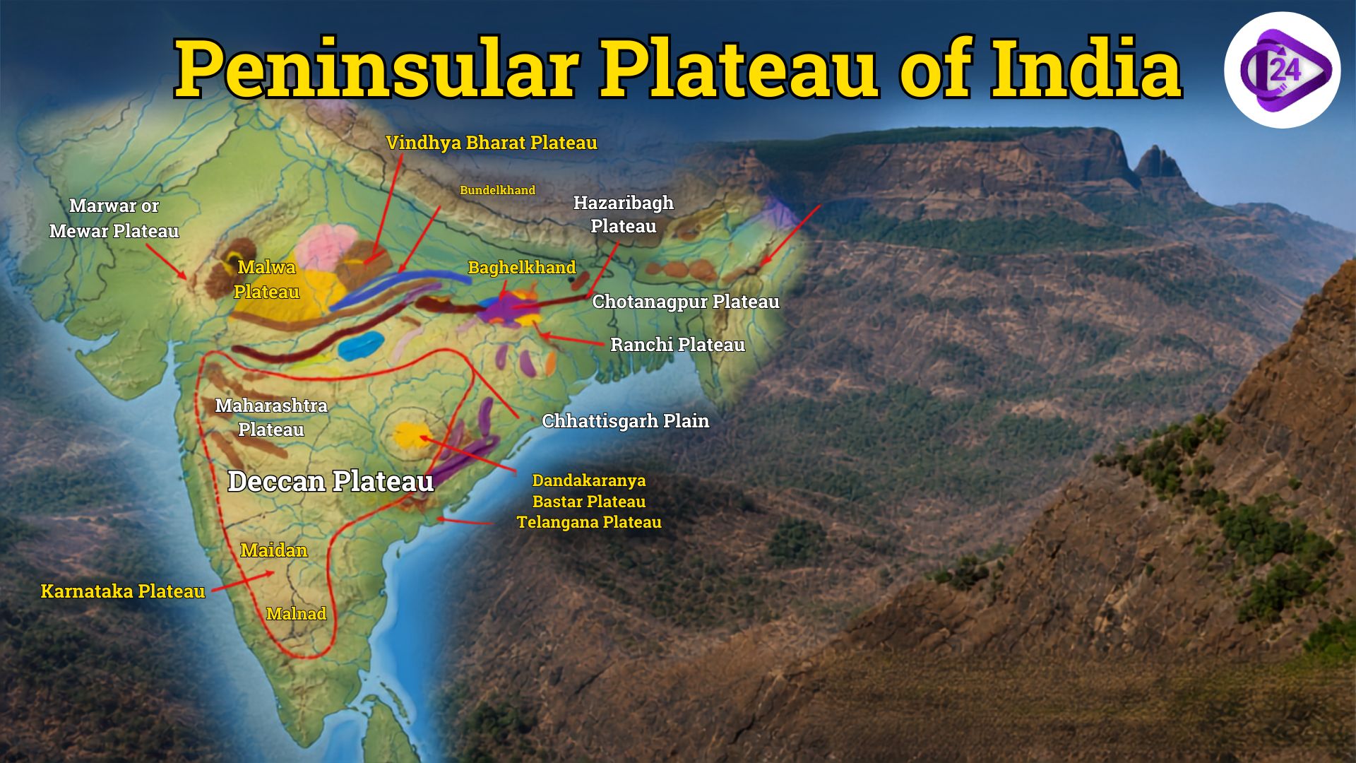
The Peninsular Plateau almost make up three-fourths of India, and it is the oldest, stable formation in nature. As a fragment of the Indian Shield, it consists of igneous and metamorphic rocks dating back to Precambrian time and has undergone very little tectonic activity for millions of years. The northern edge of the plateau is defined by the Aravalli Range, with central India being occupied from north to south by the Vindhya and Satpura ranges and then running along both coasts up to Kanyakumari. Western Ghats (Sahyadri) in the west and the Eastern Ghats.
The Peninsular Plateau, a vast expanse of land with rich minerals and forests as well as fertile soils, supplies many major rivers and is the backbone of farming, industry and economy in India.
Peninsular Plateau of India Features
The oldest and most stable physical division of India is the Peninsular Plateau. This is a triangular tableland formed from an ancient crystalline igneous and metamorphic rock contact area. Covering nearly 16 lakh sq. 1 million sq, km, this constitutes nearly half the area of India and its mineral & natural resources.
Key Features of the Peninsular Plateau
- Oldest Landmass: The earth’s oldest geological formations are of early Precambrian age.
- Triangular Form: The triangular form of the plateau has its base to the north and at Kanyakumari towards the south.
- Average Elevation: It has an elevation of 600–900 metres (2,000–3,000 ft).
- Stable Geographical Structure: It contains parts of ancient Gondwana Land and is tectonically stable with a minimum occurrence of seismic movement.
- Rock Type: Mainly igneous and metamorphic rocks such as granite, gneiss, basalt and schist;
- Limits: Surrounded in the upper west by the Aravalli Range, toward the east middle by the Vindhya and Satpura Ranges, and along both flanks by the Western Ghat and Eastern Ghat.
- Parent Categories: These are divided into the Central Highlands and Numerically Deccan Plateaus.
- River Systems: The major rivers include the Narmada and Tapi in the west, while the Godavari, Krishna, Kaveri and Mahanadi drain into the Bay of Bengal.
- Rich in minerals like coal, iron ore, manganese, bauxite, mica and limestone and with copper once found as well, it’s the mineral heartland of India.
- Deccan Plateau has a range of soil; the most important of all is black cotton soil (also known as Regur soil); it yields high crop and is highly suitable for cultivation of cotton.
- Agriculture Significance: Key crops are cotton, millets, pulses, oilseeds and sugarcane & groundnut.
- Biodiversity: Has significant forests, wildlife sanctuaries and biodiversity hotspots, particularly in the Western Ghats
- Economic Importance: Helps mining, units; hydroelectricity venture and farming henceforth assume a noteworthy part in the economy of India.
- The Western Ghats are steeper compared to the Eastern Ghats, which leads to different drainage and climate as well.
- Well-known waterfalls like Jog Falls, Hogenakkal Falls, and Chitrakote Falls are found in the area.
Peninsular Plateau of India Divisions
Generally, the Peninsular Plateau may be divided into two physiographic divisions, namely the Central Highlands and the Deccan Plateau. These divisions are distinguished by geography, altitude, drainage structure and topography.
Central Highlands Plateaus
| Plateau | Location | Key Features |
| Malwa Plateau | Madhya Pradesh, Rajasthan | Volcanic origin, black soil, Chambal basin |
| Mewar Plateau | Southern Rajasthan | Part of the Aravalli region, rocky terrain |
| Marwar Plateau | Western Rajasthan | Semi-arid region with sandy plains |
| Bundelkhand Plateau | Uttar Pradesh, Madhya Pradesh | Granite rocks, Betwa and Ken rivers |
| Baghelkhand Plateau | Madhya Pradesh, Chhattisgarh | Rich in limestone and coal deposits |
| Chota Nagpur Plateau | Jharkhand, Odisha, Bihar, Chhattisgarh, West Bengal | Mineral Storehouse of India |
| Rewa Plateau | Madhya Pradesh | Lies between Vindhya and Kaimur ranges |
| Bhander Plateau | Madhya Pradesh | Part of the Vindhyan Plateau |
| Kaimur Plateau | Madhya Pradesh, Uttar Pradesh, Bihar | Sandstone plateau, extension of Vindhyas |
| Vindhyan Plateau | Madhya Pradesh, Uttar Pradesh | Composed mainly of sandstone and limestone |
Deccan Plateau
| Plateau | Location | Key Features |
| Deccan Plateau | Southern India | Largest plateau, formed by Deccan Trap lava flows |
| Maharashtra Plateau | Maharashtra | Black cotton soil, cotton cultivation |
| Karnataka (Mysore) Plateau | Karnataka | Rich in gold, iron ore and manganese |
| Telangana Plateau | Telangana | Ancient granite rocks, Godavari & Krishna rivers |
| Andhra (Rayalaseema) Plateau | Andhra Pradesh | Red soil, drought-prone region |
| Tamil Nadu Plateau | Tamil Nadu | Bounded by the Eastern and Western Ghats |
Other Important Plateaus of India
| Plateau | Location | Key Features |
| Bastar Plateau | Chhattisgarh | Dense forests and rich iron ore deposits |
| Koraput Plateau | Odisha | Rich in bauxite reserves |
| Dandakaranya Plateau | Chhattisgarh, Odisha & Telangana | Forested tribal region |
| Ranchi Plateau | Jharkhand | Famous for waterfalls and mineral resources |
| Hazaribagh Plateau | Jharkhand | Rich coal reserves and forests |
| Meghalaya Plateau | Meghalaya | Includes Garo, Khasi and Jaintia Hills |
| Karbi Anglong Plateau | Assam | Extension of the Meghalaya Plateau |
| Nilgiri Plateau | Tamil Nadu, Kerala & Karnataka | Meeting point of the Eastern and Western Ghats |
| Anaimalai Plateau | Tamil Nadu & Kerala | Home to Anamudi, South India’s highest peak |
| Palani Plateau | Tamil Nadu | Known for Kodaikanal hill station |
| Cardamom Plateau | Kerala | Famous for spice cultivation |
| Saurashtra Plateau | Gujarat | Basaltic lava region |
| Kathiawar Plateau | Gujarat | Peninsula between the Gulf of Kachchh and Gulf of Khambhat |
| Kachchh Plateau | Gujarat | Dry plateau near the Rann of Kachchh |
| Ladakh Plateau | Ladakh | High-altitude cold desert plateau |
Key hills of the peninsular plateau of India
India’s geography, the Peninsular Plateau is bordered by and cut through by several ancient hill ranges that shape its drainage, climate, biodiversity and mineral deposit distribution. The majority of these hills consist of ancient igneous and metamorphic rocks and represent some of the world’s oldest landforms.
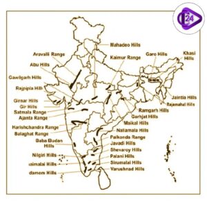
| Hill Range | Location / States | Highest Peak | Significance |
| Aravalli Range | Rajasthan, Haryana, Delhi, Gujarat | Guru Shikhar (1,722 m) | Oldest fold mountain range in India; acts as a barrier to the Thar Desert. |
| Vindhya Range | Madhya Pradesh, Uttar Pradesh, Rajasthan | Kalumara Peak (~752 m) | Separates the Northern Plains from the Deccan Plateau. |
| Satpura Range | Madhya Pradesh, Maharashtra, Chhattisgarh | Dhupgarh (1,350 m) | Lies between the Narmada and Tapi rivers; rich in forests and wildlife. |
| Western Ghats (Sahyadris) | Gujarat to Tamil Nadu along the west coast | Anamudi (2,695 m) | UNESCO World Heritage Site and one of the world’s biodiversity hotspots. |
| Eastern Ghats | Odisha, Andhra Pradesh, Telangana, Tamil Nadu | Jindhagada / Arma Konda (1,690 m) | Discontinuous mountain range cut by major rivers such as the Godavari and Krishna. |
| Nilgiri Hills | Tamil Nadu, Kerala, Karnataka | Doddabetta (2,637 m) | Junction of the Western and Eastern Ghats; famous for tea plantations. |
| Anaimalai Hills | Kerala and Tamil Nadu | Anamudi (2,695 m) | Home to South India’s highest peak and Eravikulam National Park. |
| Cardamom Hills | Kerala | South Cardamom Peak (~1,670 m) | Renowned for spice cultivation, especially cardamom and pepper. |
| Palani Hills | Tamil Nadu | Vandaravu (2,533 m) | Home to Kodaikanal and an important watershed region. |
| Mahadeo Hills | Madhya Pradesh | Dhupgarh region | Part of the Satpura system; rich in forests and biodiversity. |
| Maikal Hills | Madhya Pradesh, Chhattisgarh | Amarkantak Plateau region | Source region of the Narmada and Son rivers. |
| Rajmahal Hills | Jharkhand | Highest point ~600 m | Known for volcanic rocks and fossil-rich formations. |
| Shillong Plateau (Meghalaya Plateau) | Meghalaya | Shillong Peak (1,965 m) | Detached extension of the Peninsular Plateau, separated by the Malda Gap. |
India Mineral Resources of Peninsular Plateau
Peninsular Plateau of India, or the Peninsular plateau region, is also known for being a mineral-rich area and hence it is known as the Mineral Storehouse of India. The plateau consists of ancient igneous and metamorphic rocks and has large deposits of both metallic and non-metallic minerals. This is where the majority of India’s large mining and mineral-based industries are located. In the meantime, the Geological Survey of India ( GSI) keeps identifying and exploring new minerals across the Peninsular Plateau under the National Mineral Exploration Policy(NMEP).
Peninsular Plateau of Major Minerals
- Iron Ore: Commonly found in Chota Nagpur Plateau, Odisha, Jharkhand, Chhattisgarh, Karnataka and Goa. It is the backbone of the Steel industry in India.
- Coal: Abundant reserves of coal are found in the Damodar Valley—mainly at Jharia, Raniganj, Bokaro, and Talcher—which provide fuel for thermal power generation and heavy industries.
- Manganese: Major reserves are found in Madhya Pradesh, Maharashtra, Odisha, Karnataka and Andhra Pradesh. Manganese is vital to steel production.
- Bauxite: The iron ore obtained from this area is rich and will be used for Aluminium. Major deposits are in Odisha, Chhattisgarh, Jharkhand, Maharashtra and Andhra Pradesh, whereas the plateau also produces an enormous amount of Bauxite.
- Mica: Occurs primarily in Jharkhand, Andhra Pradesh and Rajasthan. Note: Mica, a mineral used for shine & glitter, is a key ingredient in beauty products. India was one of the most significant mica-producing nations historically.
- Madhya Pradesh, Chhattisgarh, Andhra Pradesh, Telangana and Rajasthan limestone. This is the main raw material used in the cement industry.
- Copper: Major occurrences are known from Singhbhum (Jharkhand), Malanjkhand (Madhya Pradesh) and parts of Rajasthan.
- Gold: The Kolar gold fields and the Hutti Gold Mines (Karnataka), India, have only three major gold mining regions around the country.
- Chromite: Mainly concentrated in Odisha, mainly located in Sukinda Valley, among the most chromite belts of the earth.
- Nickel, Cobalt and Critical Minerals: Found in locations in Odisha, Jharkhand, Karnataka, Maharashtra, Rajasthan, Andhra Pradesh, Madhya Pradesh and Chhattisgarh. GSI is seeking these minerals in India to help India’s energy transition and strategic sectors.
Major Mineral-Producing Plateaus
- Chota Nagpur Plateau: Iron ore, coal, mica, bauxite, uranium, copper and limestone.
- Deccan Plateau: Manganese, bauxite, iron ore, limestone, Basalt.
- Karnataka Plateau: Gold, iron ore and manganese granite
- Bastar Plateau: Iron ore, tin, bauxite and limestone.
- Koraput Plateau: Bauxite and limestone.
Economic Significance of the Peninsular Plateau of IndiaThe
Peninsular Plateau is also one of the economically important physiographic regions in India. Zambezi region, containing a wealth of mineral deposits, fertile soils, and vast river systems, forests and hydropower potential, is an enabler of many industrial and agricultural value-adding projects to the country. As stated by the Geological Survey of India (GSI) and Ministry of Mines, it holds a larger part of India’s store of metallic & non-metallic minerals, which likewise aids numerous businesses and infrastructure advancement.
Key Economic Significance – Peninsular Plateau
- Mineral Resources: The Peninsular Plateau is known as the “Mineral Storehouse of India”, which has deposits of iron ore, coal, bauxite, manganese, mica, limestone, copper,, chromite and even gold. India’s mining and manufacturing sectors is primarily dominated by these mineral industries.
- Industrialisation: Due to the availability of raw materials, large-scale industries like iron and steel, aluminium, cement, engineering, power generation and automotive manufacturing have thrived. The plateau is home to several industrial centres like Jamshedpur, Bokaro, Bhilai, Rourkela, Durgapur and Visakhapatnam.
- Black cotton (Regur) soil of the Deccan Plateau supports many cash crops like cotton and sugarcane; however; great soil is likewise reasonable to grow soybean, groundnut, pulses and millets and oilseeds; henceforth why area has significant significance in agriculture.
- Hydropower generation: The Narmada, Tapi, Godavari, Krishna, Kaveri and Mahanadi support large multipurpose projects and hydroelectric power stations as well as irrigation, electricity and drinking water.
- Forest Resources: Western Ghats forests, Chota Nagpur Plateau, Bastar Plateau and Eastern Ghats are rich in timber, bamboo, medicinal plants, lac, tendu leaves and other forest products which support a large number of forest-based industries as well as the livelihoods of tribal people.
- Mining Jobs: Mining across Jharkhand, Odisha, Chhattisgarh, Karnataka, Maharashtra and Goa provides a great amount of employment while accelerating the economic growth of the region.
- Transportation & Trade: The Peninsular Plateau has an enormous road and railway network linking mining belts, industrial centres and ports both of domestic as well as international importance.
- Energy security: Big coal reserves in the plateau and thermal power plants, Hydropower projects increase India’s renewable energy setup.
- Tourism: Hill stations, waterfalls, wildlife sanctuaries and UNESCO World Heritage Sites such as the Western Ghats attract both domestic and international tourists, contributing to economy of tourism.
- Critical Minerals: The Peninsular Plateau has the potential to become an important supplier of several critical and strategic minerals necessary for electric vehicles, renewable energy technologies, electronics and national defence manufacturing, thus enhancing resource security in India in the long run.
Challenges of the Peninsular Plateau of India
- Land Degradation: Soil erosion, deforestation, overgrazing, and unsustainable land use have resulted in the loss of soil resources; degraded soils today are less fertile and productive.
- Environmental Cost of Mining: Coal, iron ore, bauxite, limestone and manganese mining causes deforestation (destruction of vegetation), land degradation (soil erosion), air pollution (which raises the cost of sand masks for breathing) through dust emissions as well as water contamination and habitat destruction.
- Water Scarcity: Lack of proper and balanced rainfall, frequent droughts, and reduced groundwater levels lead to scarcity of water for farms, industries, and domestic uses.
- This erosion of the soil base, especially wind and water erosion related to plateau slopes and degraded forests, deteriorates the quality and productivity of agricultural land.
- Deforestation: The expansion of mining, agriculture, infrastructure and urbanisation has led to reduced forest cover and biodiversity.
- Loss of Biodiversity: Areas with ecological sensitivity such as the Western Ghats and Eastern Ghats are vulnerable to habitat fragmentation and loss of endemic species.
- Climate Change: Climate change is making high temperatures, unstable monsoons, severe droughts and extreme events negatively impact agriculture, forests and water.
- Landslides: Some areas of the Western Ghats are highly susceptible to landslips as a result of heavy rainfall, quarrying for stone aggregates, road building as well as deforestation.
- Groundwater depletion: This problem arises when groundwater is being used for irrigation and industrial purposes more than its replenishment, resulting in declining groundwater levels in many plateau regions.
- Forced displacement: Mining and the construction of large infrastructures often result in forced displacement for tribal communities and threaten their traditional means of livelihood.
- Accelerated Urbanisation: Pressure on all types of natural resources and fragile ecosystems is booming amidst rapid industrialisation and urban expansion.
- What are Forest Fires: Dry climatic conditions and human activities are causing seasonal forest fires, which cause ecological and economic losses.
- Conservation of Critical Minerals: Access to critical minerals such as lithium is growing due to the transition away from fossil fuels, which requires a focus on balancing mineral extraction with environmental protection and sustainable mining practices.
- Infrastructure Bottlenecks: Despite improvements, remote areas in plateau regions remain poorly connected by transport and irrigation networks and market access.
- Sustainable Resources Management: Due to heavy and rapid exploitation of mineral, water, and forest resources for economic development, sustainable management of these through the mining path from mine-to-metal production is still a significant policy challenge.