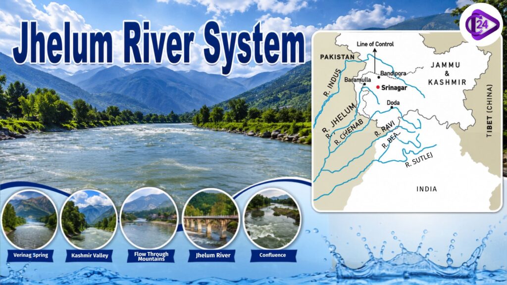
Jhelum River, or Vitasta in ancient Sanskrit texts, is an expansive river whose colour depends on its region within the Indus River System and that exudes profound geographical, cultural, and historical significance. It begins at the Verinag Spring, in the region of the foothills of the Pir Panjal Range (Jammu & Kashmir), and runs northward through the Kashmir Valley, flowing past Srinagar—the valley’s capital—and Wular Lake, then turns south as it “picks up” tributaries from surrounding mountains before entering Pakistan to join the Chenab River.
The Jhelum, which is between 700 and 725 km long, has sustained settlements, agriculture and trade for thousands of years. This place is also known as the Hydaspes River of antiquity, where Alexander defeated King Porus in 326 BCE.
Jhelum River Origin
Jhelum River flows from Cheshma (Verinag) Spring located at the foothills of the Pir Panjal Range in south eastern corner of the Kashmir Valley, Anantnag district, Jammu and Kashmir. [Source: Indus Basin Organisation] Located at an altitude of about 1,850 metres above sea level near the Banihal Pass, this perennial spring produces a small stream.
The river Jhelum was also called Vitasta (Sanskrit) in ancient texts and as Vyeth in the Kashmiri language; it is one of the major western tributaries of the Indus River System. It emerges from Verinag, flows north-west into Srinagar and then passes through the Wular Lake, entering Pakistan below it to become the Chenab River.
Jhelum River Tributaries
| Tributary | Bank | Origin | Key Regions/Features | Confluence with Jhelum |
| Lidder River | Left Bank | Kolahoi Glacier, Anantnag district, Jammu & Kashmir | Flows through the Pahalgam Valley; supports tourism, trout fishing, and irrigation. | Joins the Jhelum near Khanabal, Anantnag. |
| Sind River (Sindh Nallah) | Left Bank | Machoi Glacier near Zoji La Pass, Jammu & Kashmir | Flows through the Sind Valley and feeds Wular Lake; important for hydropower and irrigation. | Enters the Jhelum through Wular Lake. |
| Pohru River | Left Bank | Lolab Valley, Kupwara district, Jammu & Kashmir | Drains the northwestern Kashmir Valley and supports agriculture. | Joins the Jhelum near Sopore. |
| Vishav River | Right Bank | Kausarnag Lake, Pir Panjal Range, Jammu & Kashmir | Flows through Kulgam district; an important source of irrigation. | Merges with the Jhelum near Sangam, Anantnag. |
| Rambiara River | Right Bank | Pir Panjal Range, Shopian district, Jammu & Kashmir | Drains the apple-growing regions of south Kashmir. | Joins the Jhelum near Wachi, Shopian. |
| Romushi River | Right Bank | Pir Panjal Range, Jammu & Kashmir | Flows through the Pampore region; contributes to local agriculture. | Meets the Jhelum near Awantipora. |
| Kunhar River | Left Bank (Pakistan) | Lulusar Lake, Khyber Pakhtunkhwa, Pakistan | Flows through the Kaghan Valley; supports tourism and hydropower. | Joins the Jhelum near Muzaffarabad. |
| Kishanganga River (Neelum River) | Right Bank (Pakistan) | Krishansar Lake near Sonamarg, Jammu & Kashmir | Known as the Neelum River in Pakistan; flows through the Gurez Valley. | Meets the Jhelum at Domel, Muzaffarabad. |
| Poonch River | Right Bank (Pakistan) | Pir Panjal Range, Jammu & Kashmir | Flows through the Poonch region and across the Line of Control. | Joins the Jhelum near Mangla Reservoir. |
Major Hydropower Projects on the Jhelum River System
| Hydropower Project | River | Location | Installed Capacity | Commissioned/Status | Key Features |
| Uri Hydroelectric Project (Stage I) | Jhelum River | Baramulla district, Jammu & Kashmir, India | 480 MW | Commissioned (1997) | Run-of-the-river project operated by NHPC; one of the largest hydropower stations on the Jhelum. |
| Uri-II Hydroelectric Project | Jhelum River | Baramulla district, Jammu & Kashmir, India | 240 MW | Commissioned (2014) | Downstream extension of the Uri project; developed to utilise the remaining hydropower potential of the Jhelum. |
| Lower Jhelum Hydroelectric Project | Jhelum River | Baramulla district, Jammu & Kashmir, India | 105 MW | Commissioned (1978) | One of the earliest hydropower projects in Jammu & Kashmir; operated by JKSPDC. |
| Kishanganga Hydroelectric Project | Kishanganga (Neelum) River* | Bandipora district, Jammu & Kashmir, India | 330 MW | Commissioned (2018) | Run-of-the-river project on the Jhelum’s major tributary; diverts water to the Bonar Nallah for power generation. |
| Pakal Dul Hydroelectric Project | Marusudar River* | Kishtwar district, Jammu & Kashmir, India | 1,000 MW | Under construction | Located on a tributary of the Chenab River, part of the wider Indus basin hydropower network. |
| Mangla Hydropower Station | Jhelum River | Mirpur, Pakistan-administered Kashmir | 1,310 MW | Commissioned (1967); upgraded later | One of Pakistan’s largest multipurpose projects for power generation, irrigation, and flood control. |
Indus River System Guide 2026: Origin & Tributaries
Key Features of Jhelum River
- The Jhelum River is a big western tributary of the Indus River System.
- The source of this river is located at the Verinag spring in the Anantnag district of Jammu & Kashmir.
- Ancient Sanskrit texts name the river as Vitasta, and Greek accounts refer to it as Hydaspes.
- It passes through Srinagar, Wular Lake, and Kashmir Valley.
- Its total length is about 725 Km,
- Near Muzaffarabad, the Jhelum enters Pakistan and meets the Chenab River near Trimmu.
- Other important tributaries are the Lidder, Sind, Vishav, Pohru, Poonch and Kishanganga (Neelum) rivers.
- The river is used for irrigation, domestic and industrial water supply, inland fisheries, navigation and hydropower generation.
- It was famously the site of the Hydaspes Battle (326 BCE) between Alexander the Great and King Porus.
- This concept applies to water sharing under the Indus Waters Treaty (1960).