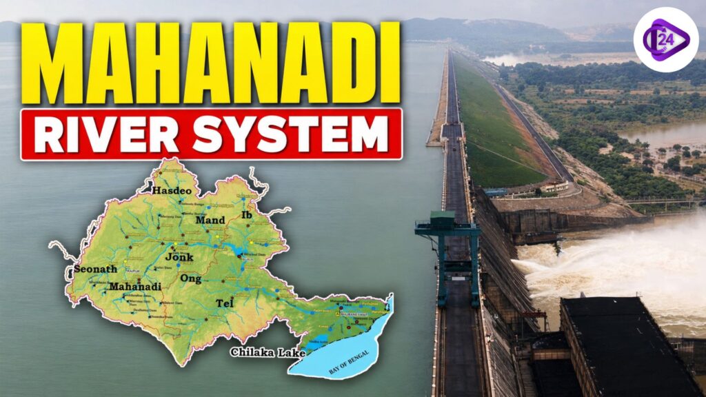
Mahanadi Riveris one of the principal east-flowing interstate river systems in peninsular India. It rises near the village of Farsiya, close to Nagri in Dhamtari district, Chhattisgarh, at a height of approximately 442 metres above mean sea level and merges with the Bay of Bengal after travelling for about 851 km. The river basin drains roughly 1,41,600 sq. State in Chhattisgarh and Odisha, with fringes in Jharkhand, Maharashtra and Madhya Pradesh. The Mahanadi is one of the few river systems in India that has a large drainage network, fertile delta and main tributaries, and enormous importance for irrigation, hydropower and water resources.
Mahanadi River System
The Mahanadi River System is an interstate river basin in east central India, also a major part of the water resources of India. It originates in the Chhattisgarh highlands and runs east across plains into a delta and the Bay of Bengal. Millions of people who reside in its basin are supported through the water for agriculture, industries, drinking purposes, fisheries, and hydropower generation. The river is also noted for major irrigation works, including the Hirakud Dam, reputedly one of the longest earthen dams in the world. The Mahanadi is an integral part of the socio-economic development in eastern India and has a wide drainage network with many tributaries.
Mahanadi River System Tributaries
The Mahanadi River System is fed by numerous tributaries originating from the Satpura, Maikal, Eastern Ghats, and Chhota Nagpur Plateau regions. These tributaries significantly enhance the river’s flow and support irrigation, agriculture, and water supply across central and eastern India.
| Tributary | Bank | Origin | Flows Through | Joins the Mahanadi Near |
| Seonath (Sheonath) | Left Bank | Maikal Hills, Chhattisgarh | Chhattisgarh | Shivrinarayan |
| Hasdeo | Left Bank | Sonhat Hills, Chhattisgarh | Korba, Janjgir-Champa | Near Shivrinarayan |
| Mand | Left Bank | Surguja Plateau, Chhattisgarh | Raigarh district | Near Chandrapur |
| Ib | Left Bank | Near Pandrapet, Chhattisgarh | Chhattisgarh, Odisha | Hirakud Reservoir |
| Ong | Right Bank | Nuapada district, Odisha | Balangir, Bargarh | Near Sonepur (Subarnapur) |
| Tel | Right Bank | Nabarangpur district, Odisha | Kalahandi, Balangir, Sonepur | Sonepur (Subarnapur) |
| Jonk | Right Bank | Chhattisgarh Highlands | Chhattisgarh, Odisha | Near Khariar region |
| Pairi | Right Bank | Gariaband district, Chhattisgarh | Raipur, Gariaband | Rajim |
| Sondur | Right Bank | Sihawa Hills, Chhattisgarh | Dhamtari district | Rajim |
Important Dams on the Mahanadi River System
| Dam / Project | River | State | Purpose | Key Facts |
| Hirakud Dam | Mahanadi | Odisha | Irrigation, Flood Control, Hydropower | Longest dam in India (25.79 km); foundation stone laid by Jawaharlal Nehru (12 April 1948); completed in 1957; created one of Asia’s largest artificial lakes. |
| Gangrel Dam (Ravishankar Sagar) | Mahanadi | Chhattisgarh | Irrigation, Drinking Water, Hydropower | One of the largest dams in Chhattisgarh; major source of irrigation and drinking water for central Chhattisgarh. |
| Dudhawa Dam | Mahanadi | Chhattisgarh | Irrigation & Water Supply | Located near the origin of the Mahanadi River in Dhamtari district; supports agriculture in the upper Mahanadi basin. |
| Hasdeo Bango Dam (Minimata Bango Dam) | Hasdeo | Chhattisgarh | Irrigation, Hydropower, Flood Control | Built on the Hasdeo River, the largest tributary of the Mahanadi; one of Chhattisgarh’s major multipurpose projects. |
| Naraj Barrage | Mahanadi | Odisha | Irrigation & Water Diversion | Located near Cuttack; regulates river flow and diverts water into the Mahanadi Delta canal system. |
| Tikarpara Barrage | Mahanadi | Odisha | Water Regulation | Situated near the Satkosia Gorge; helps regulate downstream flow of the Mahanadi River. |
Mahanadi River Basin
- Mahanadi River Basin has an area of 1,41,589 sq. km; therefore, it is among the key river basins of India.
- The basin covers most of Chhattisgarh (about 53.9%), a large part of Odisha (approximately 45.7%) and small parts of Jharkhand, Maharashtra and Madhya Pradesh.
- It is bounded to the north by the Central India Hills.
- The Mahanadi Basin is predominantly rain-fed, with the bulk of its annual rainfall falling during the Southwest Monsoon (June–September).
- Being one of the most economically important river basins in eastern India, the basin sustains many uses: irrigation, drinking water supply, hydropower generation, fisheries and industries (including agriculture).
Major Hydropower Projects on Mahanadi River
| Hydropower Project | River | State | Installed Capacity | Key Facts |
| Hirakud Hydroelectric Project | Mahanadi | Odisha | 347.5 MW | Largest hydropower project in the Mahanadi basin; developed with the Hirakud Dam. |
| Hasdeo Bango Hydroelectric Project | Hasdeo | Chhattisgarh | 120 MW | Generates power from the Hasdeo Bango Dam; important for Chhattisgarh’s electricity supply. |
| Gangrel Hydroelectric Project | Mahanadi | Chhattisgarh | 10 MW | Small hydropower project supporting regional electricity generation. |