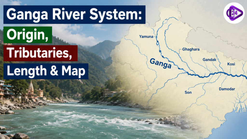
The Ganga River system is India’s most important river network in terms of geography, economy, and culture. It originates from the Gangotri Glacier (Gomukh) in the Himalayas and flows for about 2,525 km before emptying into the Bay of Bengal, forming a vast delta. The basin spreads across a large part of northern India and supports a significant population. With numerous Himalayan and peninsular tributaries, it forms a well-developed dendritic drainage pattern, making it highly relevant for UPSC-level study of physical geography and river systems.
Ganga River Origin in India
The Ganga River originates in the high Himalayas from the Gangotri Glacier at Gomukh in Uttarakhand, at an altitude of about 4,000 metres. The river initially emerges as the Bhagirathi, which is considered its primary headstream. It later meets the Alaknanda River at Devprayag, where the combined flow is officially known as the Ganga. This glacial origin ensures a perennial water supply, supported by snowmelt and monsoon rainfall, making the river crucial for India’s hydrology, agriculture, and civilisation.
Tributaries of the Ganga River
The Ganga River is sustained by an extensive network of tributaries that significantly enhance its volume, drainage capacity, and geographical reach. These tributaries are broadly classified into Himalayan and Peninsular systems based on their origin and flow characteristics. Major left-bank tributaries such as the Ghaghara River, Gandak River, and Kosi River are perennial and glacier-fed, while right-bank tributaries like the Yamuna River and Son River originate from peninsular highlands. This diverse tributary system plays a crucial role in shaping the alluvial plains and sustaining agriculture.
Yamuna River
The Yamuna River is the most important right-bank tributary of the Ganga. It originates from the Yamunotri Glacier in Uttarakhand and flows for about 1,376 km through major cities like Delhi, Mathura, and Agra before joining the Ganga at Prayagraj. It is crucial for irrigation, drinking water, and the urban economy.
Son River
The Son River originates from the Amarkantak Plateau and is a major seasonal right-bank tributary. It flows through central India and joins the Ganga near Patna. The river is known for its wide valley and fluctuating discharge.
Ghaghara River
The Ghaghara River rises near the Tibetan Plateau and is one of the largest left-bank tributaries. It carries a huge volume of water and sediments, making it highly flood-prone, especially in Uttar Pradesh and Bihar.
Gandak River
The Gandak River originates in the Nepal Himalayas and is known for its heavy sediment load. It flows into Bihar and meets the Ganga near Patna, contributing significantly to alluvial soil formation.
Kosi River
The Kosi River originates in the Himalayas of Nepal and Tibet. It is formed by the confluence of multiple streams and is infamous for frequent floods and shifting courses, earning the title “Sorrow of Bihar.”
Gomti River
The Gomti River originates from a lake near Pilibhit in Uttar Pradesh. It is a rain-fed river flowing through Lucknow and Jaunpur before joining the Ganga, playing a key role in regional water supply.
Ramganga River
The Ramganga River rises in the Kumaon Himalayas of Uttarakhand. It flows through forested and agricultural regions before merging with the Ganga near Kannauj, supporting irrigation systems.
Damodar River
The Damodar River originates from the Chotanagpur Plateau. Once known for destructive floods, it is now regulated by dams and is important for industrial and power generation activities in eastern India.
Punpun River
The Punpun River originates in Jharkhand and flows through Bihar. It is a seasonal river that contributes to local drainage and joins the Ganga near Patna.
Falgu River
The Falgu River flows through Bihar and Jharkhand and holds religious importance, especially near Bodh Gaya. It eventually merges with the Punpun River.
Karamnasa River
The Karamnasa River originates in the Kaimur hills and flows along the Bihar-Uttar Pradesh border before joining the Ganga. It is a seasonal river with regional importance.
Tamsa River
The Tamsa River rises from the Kaimur Range and flows through Madhya Pradesh and Uttar Pradesh before joining the Ganga. It is historically and geographically significant.
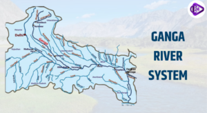
Right and Left Bank Tributaries of the Ganga River
Classification Basis: Tributaries of the Ganga River are divided into left and right banks based on the direction from which they join the main river
Left Bank Tributaries: Originate from the Himalayan region north of the Ganga
Major Left Bank Rivers: Ghaghara River, Gandak River, Kosi River, Gomti River, Ramganga River, Burhi Gandak River, Mahananda River
Characteristics: Perennial flow, glacier-fed, high sediment load, frequent flooding in Bihar and eastern UP
Right Bank Tributaries: Originate from the peninsular uplands south of the Ganga
Major Right Bank Rivers: Yamuna River, Son River, Damodar River, Punpun River, Karamnasa River, Tamsa River
Characteristics: Mostly seasonal, rain-fed, flow over hard rock surfaces, broader valleys
Geomorphic Role: Left bank rivers build fertile alluvial plains; right bank rivers contribute to plateau drainage
Hydrological Importance: Maintain discharge, groundwater recharge, and basin-wide connectivity
Economic Significance: Support irrigation, agriculture, settlements, and regional economies
Dams on the Ganga River System
| Dam Name | Location (City/State) | River / Project | Purpose |
| Tehri Dam | Tehri, Uttarakhand | Bhagirathi River / Tehri Hydroelectric Project | Hydropower, irrigation, flood control, and drinking water |
| Koteshwar Dam | Uttarakhand | Bhagirathi River / Koteshwar Project | Hydropower generation, downstream regulation |
| Farakka Barrage | Murshidabad | Ganga River / Farakka Project | Diverts water to the Hooghly River for navigation |
| Bansagar Dam | Madhya Pradesh | Son River / Bansagar Project | Irrigation, hydropower |
| Rihand Dam | Uttar Pradesh | Rihand River / Rihand Project | Hydropower, irrigation |
| Maithon Dam | Jharkhand | Damodar River / Damodar Valley Project | Flood control, power generation |
| Panchet Dam | Jharkhand | Damodar River / Damodar Valley Project | Flood control, hydropower |
| Tilaiya Dam | Jharkhand | Damodar River / DVC Project | Irrigation, flood control |
| Durgapur Barrage | West Bengal | Damodar River | Irrigation, water supply |
| Kosi Barrage | Bihar (near Nepal border) | Kosi River / Kosi Project | Flood control, irrigation |
| Gandak Barrage | Bihar (Valmikinagar) | Gandak River | Irrigation, flood control |
Ganga River – Panch Prayag
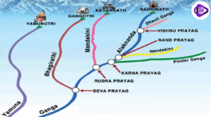
| Prayag Name | Confluence Rivers | Location (District) | Key Significance |
| Vishnuprayag | Alaknanda River + Dhauliganga River | Chamoli | First confluence; near Joshimath, important in upper Himalayan drainage |
| Nandaprayag | Alaknanda + Nandakini River | Chamoli | Named after King Nanda; important for regional hydrology |
| Karnaprayag | Alaknanda + Pindar River | Chamoli | Associated with Karna from Mahabharata; key mid-Himalayan confluence |
| Rudraprayag | Alaknanda + Mandakini River | Rudraprayag | Religious significance; route to Kedarnath |
| Devprayag | Alaknanda + Bhagirathi River | Tehri Garhwal | Final confluence where Ganga is officially formed |
Ganga-Brahmaputra Delta
The Ganga-Brahmaputra Delta is the world’s largest and most dynamic delta, formed by the combined deposition of sediments by the Ganga River and Brahmaputra River. It spreads across India and Bangladesh, covering about 100,000 sq km. Characterised by distributaries, marshes, and mangrove forests, it includes the Sundarbans, a UNESCO World Heritage Site. The delta is highly fertile but prone to floods, cyclones, and erosion, making it both agriculturally rich and environmentally vulnerable.
Conclusion – Ganga River System
The Ganga River System is a vital lifeline of India, supporting millions of people through agriculture, water supply, and cultural practices. Its extensive network of tributaries, fertile alluvial plains, and vast delta region make it one of the most significant river systems in the world. Despite its importance, challenges like pollution, flooding, and overuse persist. Sustainable management and conservation of the Ganga basin are essential to ensure ecological balance, economic development, and long-term water security for future generations.